
If you are planning to run a trail Ultra, finding training routes on trails when you can clearly is the right thing to do, but it’s not always that easy…
So how do you find training routes, and what else should you consider?
Shoes
Once you’ve chosen a shoe for an event you’ll want to train in them. Road running in trail shoes can chew through the soles quickly, but you need to train in your event shoes. And you need to practice on terrain similar to your event whenever you can. So eventually you do need to find trails to train on.
Trail vs Tarmac
Sometimes you just can’t run trail – we have an article on how to compensate here. When you live somewhere that you can’t step onto a trail from the door and never set foot on tarmac (wouldn’t that be lovely), it can be tempting/necessary to drive (or train or bus) to somewhere that you can. And this is a great option… BUT…
Adding Pressure?
However, Ultra training is time consuming as it is and travelling to run adds even more time to your schedule. In our experience it adds an extra dimension of pressure (and stress). You are always watching the clock and thinking that I need to be getting back now…inevitably unless you can remove this pressure (more in a moment) it can remove some of the enjoyment of the run, or worse, end up with you cutting short a run so you can get back on time!
Removing the pressure
So, how do we do it? Firstly, remove the perceived time pressure.
Can you go somewhere that the family can come along and entertain themselves while you are out running? Or can you take a ‘me day’ and block out enough time to remove the pressure?
Booking time out for you can lead to a great adventure.
Equally catching up with the family at a café when you’ve all had your separate adventures is great fun!
Travelling to run requires planning and preparation – it’s all valuable for your Ultra journey – the better you plan the less pressured it feels. You should also practice post-event ‘admin’. Getting clean, fed, warm, hydrated etc when you get back to your transport adds another dimension that will make your actual post-event much easier.
How do we find training routes?
There are a number of apps that let you find and plot training routes (komoot, mapmyrun are two big ones), but for us the best choice is an OSMaps subscription. You can find discounts and get a year’s total access to all OSMaps for around £20 (£23.99 full price). This gives you the ability to plan routes on a laptop/PC, print as many maps as you like. You can then follow the route using the app on your phone. Make sure you take a power bank to keep your phone charged!
With the app you literally cannot get lost – Honest! OK you always know exactly where you are, that just might not be where you thought, or wanted to be! And if you have a watch that takes routes you can download the gpx file to your watch and navigate using that.
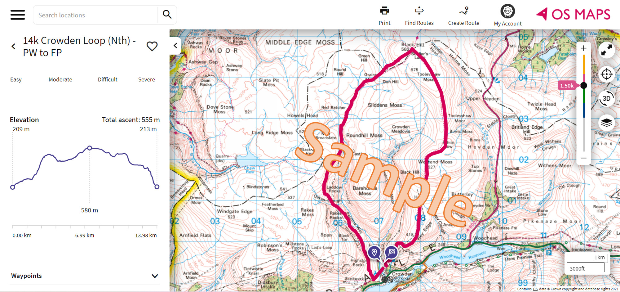
We just pick an area and using the OS Map start looking for obvious trails (long distance paths are good to follow) and potential loops; if you print an area highlighting the paths/trails will allow you to see how to start linking things together. You can also cross-reference Strava heatmap to see where people actually run. Strava does offer routes but the majority are on road.
Picking a training route
Ideally try to make your training runs match your event route (researching your event’s route). Match the terrain (forest tracks, canal towpaths etc), and the height profiles including where the hills are in a route. If your event route has all the hills at the end, make your training runs have lots of hills at the end so you get used to the feelings. Plotting a route on any of the apps mentioned will show you the vertical profile.
Safety
Safety is always a key factor, most areas have good mobile coverage if you need picking up. Even so, make sure you leave someone with your planned route. Tell them how long you’ll be, where you’ll stop if you need to, and what you’d like them to do if you don’t contact them on time.
Things to consider:
- Set up your phone so you can text to 999. Send the message ‘register’ as an SMS to 999 and then follow the instructions you get back.
- Add what3words to your phone – useful (if you have a signal) for giving a precise location – used by most emergency service control rooms now.
- OSMaps also allows you to get a location even with no signal, you can download the maps for a route to your phone.
And of course you’ll be carrying your Ultra pack so you’ll have warm layers, hat, waterproofs, food, self-aid kit etc anyway
It’s an adventure
Most importantly, enjoy exploring and finding new places, new things. It’s a fantastic adventure – as soon as you start looking at maps you’ll start finding places you didn’t know existed!